Großglockner-Hochalpenstraße
The
Großglockner-Hochalpenstraße, also
known as the Großglocknerstraße, is an alpine toll-road
that
bisects the Austrian Nationalpark Hohe Tauern from north to south. The
road was constructed from 1930-1935 as part of an economic stimulus
package
to combat the effects of the world-wide recession. During those five
summers,
3000 workers labored to accomplish the unprecedented task of laying
over
40 km of road with, more than 6 km of those at altitudes over 2200
m.
|
|||||||||||||||||
 |
 |
 |
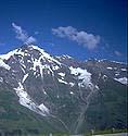 |
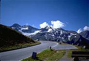
| View
of the southeast faces of the Fuscher/Kapruner
Kamm from the Hexenküche (the Witches' Kitchen, 1850 m @ km 23),
Großglockner-Hochalpenstraße,
Nationalpark Hohe Tauern, Austria
--
details on each mountain can be obtained by clicking on the individual
images that create this panoramic composite.
At the Hexenküche, road workers found old chain gang links during the construction of the Großglocknerstraße. These chain links were dated to the 17th century when they were used in the transport of prisoners from Salzburg to forced labor camps in Venice. |
|||
A bit further up the road you will encounter the Fuschertörl, 2428 m @ km 27.4, where the architect Clemens Holzmeister build a chapel in memory of the workers that lost their lives during the construction of the Großglockner-Hochalpenstraße. During bad weather days, you can observe the mighty force of the mountain climate, as clouds rush up hill at remarkable speeds and engulf you before you can walk 100 m to the car. At km 33.7, the Großglockner-Hochalpenstraße reaches its highest road passing at the Hochtor. From the late middle ages to the 17th century, Hochtor was the third most important trade route between Venice and Germany. Even today, remains of the old roman trading route, Römerweg, are clearly visible next to the modern road.
 At
km 40 the Großglockner-Hochalpenstraße splits; one branch
leads
south towards Lienz, the other, a dead-ended branch, detours towards
the
Großglockner basin. Early along the dead-end branch, the road
reaches
the Glocknerhaus (2132 m). During the
early
1900's, the Pasterze glacier (Pasterzenkees) was much larger than it is
today, and the Glocknerhaus was the main hut used for assaults on the
Großglockner.
Due to the high incidence of avalanche in this portion of the road, a
protective
roof was erected over the Großglockner-Hochalpenstraße to
prevent
seasonal damage to its surface (see photo on the left).
At
km 40 the Großglockner-Hochalpenstraße splits; one branch
leads
south towards Lienz, the other, a dead-ended branch, detours towards
the
Großglockner basin. Early along the dead-end branch, the road
reaches
the Glocknerhaus (2132 m). During the
early
1900's, the Pasterze glacier (Pasterzenkees) was much larger than it is
today, and the Glocknerhaus was the main hut used for assaults on the
Großglockner.
Due to the high incidence of avalanche in this portion of the road, a
protective
roof was erected over the Großglockner-Hochalpenstraße to
prevent
seasonal damage to its surface (see photo on the left).
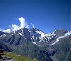
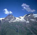
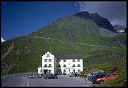
A few kilometers up the road, the Großglockner branch of the Hochalpenstraße reaches its conclusion at the Kaiser-Franz-Josefs-Höhe, 2369 m. At this location you will find a large multi-level parking garage, a bank (which is pretty worthless given that they don't have an ATM nor do they accept VISA), gift shops, a restaurant, access to the Franz-Josefs-Haus (2418 m), and an observation deck in which you will be humbled by the view of Großglockner (3798 m), tallest mountain in Austria, and the Pasterzenkees, longest glacier in eastern Europe.
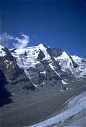
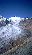
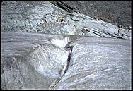
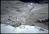
Guarding the impressive north face of the Großglockner is the Pasterze glacier which is 10 km long, 300 m deep, and has a surface area of 20 sq. km. In recent years it has receded over 50 m as shown by year markers painted on its rock bed. From the Kaiser-Franz-Josefs-Höhe, the Pasterzenkees can be accessed by a class 1 trail (i.e., loose footing) or via a funicular rail which descends 143 m. When this rail was constructed decades ago, it used to reach the surface of the glacier. Today, the ice has receded so much that the rail only reaches the half way point between the Kaiser-Franz-Josefs-Höhe and the Pasterzenkees.
At the end of the hike, the surface and the terminal talus of the Pasterzenkees are easily reachable. The glacier is very stable and walking unroped on it is fairly safe, only requiring the assistance of a bit of common sense.
 |
 |
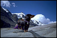 |
| Crevasse near the end of the Pasterzenkees, Großglocknergruppe, Nationalpark Hohe Tauern, Austria. | People wandering at the base of the terminal talus of the Pasterzenkees, Großglocknergruppe, Nationalpark Hohe Tauern, Austria. | Eduardo enjoys the early afternoon sun at the Pasterze glacier, Großglocknergruppe, Nationalpark Hohe Tauern, Austria. |
|
|
|
|
![]() Pedro
I. Espina©1998
Pedro
I. Espina©1998